


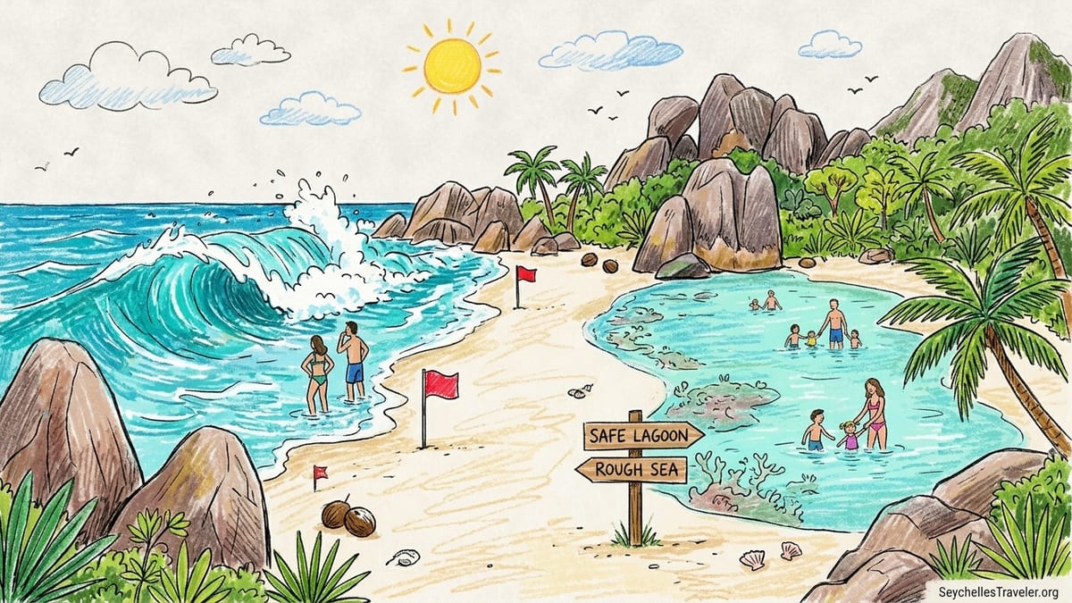
On 16 July 2026 I stood at the high-tide line on Anse Intendance, on the southwest coast of Mahé, watching walls of turquoise water collapse in thunderous succession. It was late afternoon in the cool, dry southeast trade-wind season, the sky a clean blue, and the palm trees behind me rattled in a steady onshore wind. On Instagram this same scene looks like the ultimate swim-in paradise. In person, the shore break was slamming down so hard that even the local bodyboarders were staying unusually close to shore. I had come intent on a long swim and some snorkeling. Instead, I walked away dry, after a brief attempt to wade in left me stumbling backwards, sand ripped from under my feet by a powerful backwash that felt like a conveyor belt dragging my legs toward the deeper, churning water.
The Moment I Realised “Picture-Perfect” Did Not Mean Swimmable
That afternoon at Anse Intendance was my third day on Mahé and the second time rough seas had rewritten my plans. Two days earlier, I had abandoned a planned snorkel session at the northern end of Beau Vallon because the water was milky with suspended sand and the sets were closing out across the bay. Locals told me the southeast trade winds had been blowing harder than usual for July, pushing swell into normally sheltered corners of the island. On paper, July is a popular month to visit. On the sand, the conditions were telling a different story.
At Anse Intendance, there was no protective reef keeping the open Indian Ocean at bay. The beach shelves down quickly, and the first step into the water already felt deeper than the gentle lagoon shelves I had known on other islands. A series of larger sets rolled in while I watched. Each wave reared up, then crashed with the full weight of the ocean directly onto the steep sandbank. A man who had been swimming waist-deep for photos was knocked off his feet and tumbled like laundry. He emerged unhurt but shaken, his partner quietly folding away her phone.
Later, a driver I spoke with in Anse Royale put it bluntly: during the southeast trade-wind months, he brings families to Intendance to take photographs, then drives them back to lagoon beaches like Anse Royale or Anse a la Mouche if they want to swim. That separation between “spectacular to look at” and “sensible to swim in” is the thread that would run through the rest of my time in Seychelles.
What surprised me was not that some beaches are rough. It was how far the reality on the water diverged from the carefree imagery in hotel brochures and generic online guides. I arrived with the lazy assumption that in a tropical archipelago every blue bay is swimmable year-round. After a week moving between Mahé and La Digue, speaking to local guides and reading official safety advice, that assumption looked not just naive but actively risky.
Understanding Seychelles’ Two Wind Seasons and Why They Matter
The Seychelles Meteorological Authority and government climate documents divide the year into two dominant wind seasons separated by short transition months. From roughly December to March, the islands are under the influence of the northwest monsoon, which brings warmer, more humid air and periods of heavy rain. From about May to September, the southeast trade winds take over, bringing cooler, drier weather but also more persistent and often stronger winds.
Climate guides from Seychelles’ meteorological services describe the southeast trade-wind period as a relatively dry, windy season, with the trades peaking around July and August. During these months, wind speeds over the inner islands commonly reach levels that affect sea conditions, making nearshore waters choppy and pushing swell onto exposed coasts. In contrast, the northwest monsoon period has lighter, more variable winds but more frequent heavy showers and squalls that can arrive quickly and temporarily roughen the sea.
This shift in wind direction has a direct, very practical consequence for swimmers: it broadly swaps which coasts are more exposed. Local safety guidance and recent beach safety publications explain it in simple terms. During the northwest monsoon months, west-facing beaches on islands like Mahé and Praslin often feel more of the swell and can see stronger currents. When the southeast trades dominate from May to September, the emphasis switches to east and southeast coasts, including the surf-battered side of La Digue.
Of course, it is not as simple as a single rule that “west is bad in January, east is bad in July.” Island topography, offshore reefs and the shape of individual bays all influence how energy from the open ocean is focused or dispersed. What matters is that seasons do not just change the air temperature or the chance of rain. They can radically transform the personality of a beach, turning a calm lagoon into a confused washing machine or leaving a normally rough bay temporarily glassy. Any plan that assumes the sea behaves the same way year-round is starting from the wrong premise.
Exposed Ocean Beaches: Anse Intendance, Grand Anse and Petite Anse
Among Seychelles’ most photographed beaches are those that face the open ocean with little or no reef protection. Anse Intendance on Mahé, and Grand Anse and Petite Anse on La Digue, fall squarely into this category. Their drama is undeniable. The sand is wide, the granite headlands frame the scene, and the waves march in unfiltered from deep water. These are the beaches you see on posters in European travel agencies, the ones that anchor advertising for high-end resorts.
Yet official and independent descriptions are strikingly consistent in their caution. Recent beach guides and tourism advisories describe Anse Intendance as a “wild” beach with strong surf, especially from May to September, and emphasise that there is no offshore reef and usually no lifeguard presence. Seychelles’ own Beach and Sea Safety Guide lists very limited lifeguard coverage overall, with lifeguards generally stationed at a small number of popular beaches such as Beau Vallon on Mahé and Anse Lazio or Côte d’Or on Praslin, and not at Intendance or most remote bays.
Grand Anse on La Digue carries similar warnings. It is the island’s longest beach, facing the southeast and directly exposed to swell. There is no fringing reef to disperse the force of incoming waves, so the surf often breaks heavily on the shore. Seychelles tourism information recognises that strong offshore currents and rip currents are common here during the southeast trade-wind season, and that swimming can be dangerous when the sea is up. Some guides describe official warning signs on the beach indicating dangerous currents and advise that Grand Anse is more suitable for experienced bodyboarders than for casual swimmers.
Petite Anse and Anse Cocos, reached by trail from Grand Anse, share much of this exposure. In my own July visit, Grand Anse was stunning but intimidating. The waves arrived in consistent, powerful sets. Two experienced local surfers took short rides close to shore, but everyone else stayed knee-deep or on the sand. Standing at the waterline, I could feel the sand being scooped from under my feet with each retreating wave, the backwash tugging harder than I was comfortable with. It was a beach to admire, walk and photograph, not to treat as a casual swimming spot.
Lagoon Beaches: Anse Royale, Anse Volbert and Anse Source d’Argent
In deliberate contrast, many Seychelles beaches sit behind fringing reefs that create calm, shallow lagoons. Anse Royale on Mahé’s southeast coast, Anse Volbert (also known as Côte d’Or) on Praslin, and Anse Source d’Argent on La Digue are prime examples. Here, the coral reef, often just offshore, acts as a natural breakwater. Waves lose most of their energy on the barrier, and the water inside the lagoon is typically smoother and shallower.
On a calm July morning in Anse Royale, after the blowy afternoon at Intendance, the difference felt almost exaggerated. Inside the reef the water was waist-deep for several dozen metres, over a sandy bottom with scattered coral heads. Small sets of wavelets rippled across the surface, but there was no sense of being tugged seaward. Locals were standing chest-deep, chatting. Children paddled on inflatable rings. A snorkel guide I spoke to pointed to a visibly darker band beyond the reef crest and told me simply, “That side today is for boats, not for you.”
Information from dive operators and snorkeling guides around La Digue paints the same picture at Anse Source d’Argent. The famous granite and lagoon combination here is sheltered by a complex reef system that keeps the inner channels relatively protected in many conditions, particularly when the wind is blowing from the southeast. Visibility can still be reduced by sand and seagrass, and currents vary with the tide, but the physical risk to an average swimmer is generally lower than at the island’s ocean-facing east-coast beaches.
Yet even lagoon beaches are not universally benign. During the northwest monsoon months, stronger west and northwest winds and associated swell can wrap around island corners and stir up normally placid lagoons. Local safety advice stresses that even on supposedly “safe” family beaches, swimmers should look at actual conditions on the day and seek local guidance, especially when traveling with children or non-swimmers.
Depth, Rip Currents and the Illusion of Safety in a Pretty Photograph
One of the most striking disconnects between marketing and reality in Seychelles lies in how depth and currents are presented, or rather not presented. In advertising photographs, it is almost impossible to tell whether the water goes from ankle-deep to head-deep in two steps, or whether there is a steep drop-off just beyond the person posing on the shoreline. Many granite island beaches, particularly on exposed coasts, have a sharp slope that creates a plunging shore break. For swimmers, that combination of steep sand and powerful waves is precisely what generates dangerous backwash and rip currents.
Rip currents are not unique to Seychelles, but they take on particular significance here because the surf at open-coast beaches breaks in multiple channels and sandbars rather than the long, tidy bars seen on some continental coasts. Local safety commentary notes that rip channels in Seychelles can be harder to spot from the beach, with less obvious discolouration or flat patches. When waves pile water onto the shore, that water must return seaward somehow. Where it funnels back through a narrow gap in the breaking waves, a swimmer can be swept seaward quickly, even on a day that looks relatively modest from the sand.
Official guidance from Seychelles’ Beach and Sea Safety Guide and international travel advisories highlights a few core principles: do not swim alone; avoid going out of your depth on rough days; and if caught in a current, do not attempt to swim directly back to shore against it. Instead, swim parallel to the shoreline to exit the rip, then angle back in. The problem is that many visitors have never practised this in real conditions. For an inexperienced swimmer, even knee-to-waist-deep water at a beach like Grand Anse can be unnerving once the backwash starts dragging at their legs.
This is where family suitability diverges sharply from photographic appeal. The dramatic, thundering surf that makes Anse Intendance the postcard of a lifetime is, in the very same moment, a poor choice for young children, weak swimmers, or anyone whose idea of a good swim is a leisurely float. By contrast, photographs of the shallower, seaweed-streaked lagoon at Anse Royale or Anse a la Mouche may look less pristine, yet these are often the beaches where Seychellois families actually take their children to learn to swim.
How Generic Guides and Hotel Marketing Mislead on Swimming Conditions
In planning my trip, I relied heavily on popular online travel platforms and resort websites. Most of them praised Anse Intendance and Grand Anse in almost identical terms: “perfect for swimming,” “ideal for all swimmers,” “year-round swimming beach.” Few mentioned currents explicitly. Seasonal caveats were rare and often buried at the bottom of a page. By the time I dug into more specialised safety resources and government advisories, I realised how incomplete that picture had been.
Hotel advertising has a structural incentive to focus on what is visually stunning and geographically convenient. A property perched above an exposed bay is unlikely to lead with “swimming may be unsafe outside calm days” in its brochure. Instead, it will showcase aerial shots of aquamarine surf and palm-framed sand. When safety is mentioned, it may be couched in vague generalities about “exercising normal caution,” which a traveler from a landlocked country might reasonably interpret as a reference to sunburn or stepping on a sea urchin rather than being knocked off their feet by a heavy shore break.
Generic travel guides contribute to the confusion when they treat entire islands as uniform. Phrases such as “Mahé is great for swimming year-round” or “La Digue beaches are calm lagoons” gloss over the stark contrast between, say, Beau Vallon and North East Point on Mahé, or between Anse Source d’Argent and Grand Anse on La Digue. Official safety documents and seasoned local guides instead emphasise that conditions vary markedly not just between islands but between neighbouring bays, and that exposure can flip with the season.
In my case, this played out in a small but telling way. I had booked a guesthouse near Grand Anse on La Digue primarily because a guidebook described it as “a long, beautiful swimming beach away from the crowds.” When I arrived in July, the guesthouse owner cheerfully corrected the impression. “We tell guests this beach is for walking and watching the waves at this time of year,” she said. “If they want to swim, we send them to Source d’Argent or back to the lagoon side.” It was advice I gratefully followed, but it underscored how easily off-season visitors could arrive with the wrong expectations.
Learning to Read the Sea and Use Local Knowledge
What ultimately made the difference on this trip was not a deeper knowledge of meteorology, but a shift in habits. I began treating each planned swim as a decision that needed fresh information, not as an automatic reward for reaching a photogenic beach. That meant a few concrete changes. Before leaving my accommodation, I would ask staff where they themselves would swim that day, given the wind and swell. On La Digue, bike rental shops were a surprisingly good source of up-to-the-minute advice, because they see where people are actually going and returning from.
On arrival at a beach, I forced myself to pause. Were waves breaking directly on steep sand or on an offshore reef with only smaller ripples reaching the shore. Was the water clear or stirred into an opaque churn. Could I see any sideways movement of foam that hinted at a current running alongshore. If other people were in the water, where were they relative to the breaking waves, and did any of them seem to be locals who understood the beach. These are simple observations, but in Seychelles they can spell the difference between a joyful swim and a frightening one.
I also adjusted how I approached snorkeling. On calm mornings, sheltered lagoons like Anse Volbert and Anse Royale offered pleasant, if sometimes slightly cloudy, snorkeling over seagrass and patchy coral, with moorings for small excursion boats. On rougher days, visibility dropped dramatically even in these lagoons, and the combination of chop at the surface and low visibility below made snorkeling unappealing and arguably unsafe. In practice, that meant skipping several planned snorkel sessions rather than insisting on the itinerary I had sketched weeks earlier at my desk.
Crucially, I stopped assuming that the presence of other swimmers automatically meant conditions were safe. In Grand Anse, a group of visitors were bodyboarding near the shore on a day when the waves were booming. A local guide quietly pointed out that a rip current often forms near the rocks at one end of the bay and that, if caught, the best escape would be to swim sideways towards the middle of the beach, not back towards the rocks. Without that local context, I would have stood on the sand still believing this was simply a thrilling, if slightly wild, play session in the waves.
How I Would Plan Islands, Hotel Locations and Beaches Differently Next Time
With hindsight, my primary mistake on this first trip was planning primarily around postcard beaches rather than seasonal swimming conditions. I booked July nights near exposed beaches like Grand Anse on La Digue and within easy reach of Anse Intendance on Mahé, assuming I could admire the surf at dawn and then slip into the water for a swim. Instead, I often found myself cycling or driving to more sheltered bays while paying for a location premium I did not fully use.
If I were planning a return trip, I would structure my choices around the wind seasons and specific bays. In the southeast trade-wind months from May to September, I would prioritise accommodation near more sheltered coasts and lagoon beaches. On Mahé, that might mean basing myself near Anse Royale, Anse à la Mouche or the northwest coast around Beau Vallon, while still visiting Intendance and Takamaka in the cooler hours to walk and photograph rather than swim. On La Digue, I would choose somewhere within easy cycling distance of Anse Source d’Argent and the island’s western and northwestern coves, treating the east-coast beaches as scenic day trips.
During the wetter northwest monsoon months from December to March, with a greater chance of swell and onshore winds affecting west-facing beaches, I would flip the logic. Lagoon-protected bays on the east and northeast sides of islands such as Anse Volbert on Praslin would move up my list, while I would take a more cautious approach to long swims at Beau Vallon or other open west-coast bays when the swell was running. In both seasons, I would build in flexible, unscheduled days specifically to adjust for changing conditions.
Beyond location, I would budget a little time before the trip to read the Seychelles Tourism Department’s Beach and Sea Safety Guide and my own government’s latest country information. This is not about alarmism. It is about aligning expectations with how the sea actually behaves around steep, reef-framed granitic islands. I would also pay closer attention to whether a hotel realistically offers sheltered swimming on its doorstep or simply convenient access to a beach whose character can swing from benign to hostile with a change in wind.
Finally, I would frame boat trips and snorkeling excursions as weather-dependent rather than date-dependent. On this trip, a planned half-day snorkeling tour from Mahé’s east coast was postponed twice in a row because wind and swell made the outer reef sites too rough. The operator offered alternative lagoon sites, but was explicit that guests who expected mirror-flat seas in July had often been misled by generic “year-round snorkeling” promises online. Next time, I would hold off booking such trips until on the ground, when I could match the timing to an actual forecast and the advice of people who spend most of their working lives watching these waters.
Month-by-Month Planning Guide for Safer Swimming
Any attempt to compress Seychelles’ nuanced microclimates into a simple calendar is bound to be approximate, but patterns drawn from meteorological information, tourism guidance and local experience are still useful. The key is to treat them as a starting framework and then refine your plans with real-time advice once you arrive.
From December to March, during the northwest monsoon, visitors can expect warmer, muggy weather with a higher chance of heavy showers or thunderstorms. Sea conditions during this period can be unsettled on west and northwest-facing coasts, with more frequent onshore winds and swell days. Families who prioritise easy swimming may prefer hotels with access to protected lagoons on more sheltered coasts, while using calmer spells to enjoy west-coast sunsets and walks. High holiday demand in late December and early January means that last-minute changes of plan can be harder to accommodate.
From May to September, the southeast trade winds bring lower humidity and more persistent wind, which is often welcome on land but translates offshore into choppier seas and stronger surf on east and southeast coasts. This was exactly the pattern I encountered at Anse Intendance and Grand Anse in July. Swimmers during these months might look first to bays that face north, northwest or sit behind substantial reef systems. Kite surfers and windsurfers, by contrast, may actively seek out stronger wind and rougher water, but they usually do so with local guides or instructors, not as first-timers alone.
The shoulder or inter-monsoon months of April and October, and often parts of May and November, are widely regarded by local tourism operators as particularly favourable for swimming and snorkeling, with lighter winds and calmer seas. This does not mean every day is perfect. Rain showers and brief squalls can still occur, and swells generated far out in the Indian Ocean can arrive even on otherwise calm days. Yet if I were planning a trip with a strong emphasis on in-water activities, I would now target these transition periods first and give myself flexibility inside them to move between island coasts.
Below is a generalised month-by-month planning table for swimmers, based on seasonal patterns and how I would approach choices differently next time. It is intended as a practical planning aid rather than a guarantee of conditions.
January: Peak of the wetter northwest monsoon. Expect humidity and heavy showers. West-facing beaches like Beau Vallon can see more swell and variable currents. I would base myself near lagoon beaches with the option to visit west coasts on calmer days.
February: Still within the northwest monsoon but sometimes with slightly fewer storms. Some days of very calm seas occur, alternating with rougher spells. I would keep plans flexible and ask daily about conditions on specific beaches.
March: Gradual easing of northwest monsoon influences. Often a mix of calm, hot days and remaining showers. A reasonable month for swimming on multiple coasts, but still worth checking west-coast surf before long swims.
April: Classic inter-monsoon month with generally lighter winds and relatively calm seas. My top choice for a swim-heavy itinerary, with freedom to combine both exposed and sheltered beaches, always with attention to local advice.
May: Onset of the southeast trade winds. Early May can resemble April, while later in the month the wind strengthens. I would start to treat east and southeast coasts more cautiously and lean toward lagoon beaches and northwest-facing bays.
June: Southeast trade winds established. Choppier seas and stronger surf on east and southeast coasts. Beautiful for photographs at exposed beaches such as Grand Anse, but I would prioritise swimming in sheltered lagoons and north or northwest-facing bays.
July: Peak of southeast season, matching my own experience at Anse Intendance and Grand Anse. I would avoid planning accommodation that relies on open, exposed beaches for daily swimming, and instead base myself near protected shores while visiting dramatic surf beaches for walks and photos.
August: Conditions similar to July, with strong trades and often rough seas on exposed coasts. Families and cautious swimmers would likely be happiest around lagoon beaches and north-facing bays, while consulting operators for any planned boat trips.
September: Southeast trades begin to ease, though some years remain windy into late month. A transitional time when east-coast beaches can start to calm, but I would still treat them conservatively until I saw several genuinely settled days.
October: The second inter-monsoon period with lighter winds and, in many years, some of the calmest seas. Another excellent month for swimming and snorkeling, with flexibility to enjoy a wider range of beaches, still framed by attention to local sea reports.
November: Transition toward the northwest monsoon. Conditions can swing between calm and stormy. I would watch forecasts closely and adjust between islands and coasts if a particular week looked unsettled on one side of an island.
December: Onset and establishment of the wetter northwest monsoon, especially later in the month. High demand around the festive season coincides with a greater chance of squalls and messy surf on some west-facing beaches. I would again choose accommodation with reliable access to protected lagoons and build in indoor or inland alternatives for wet days.
The Takeaway
My week in Seychelles did not match the seamless, year-round swim paradise imagined by brochures and generic guides. It was more interesting than that. It was a lesson in how a small shift in wind and season can fundamentally reshape the sea, and in how a person with limited ocean experience, like me, can travel more safely by paying attention to those changes. There is no single “safe” or “unsafe” island here. There are particular beaches, on particular coasts, that respond in particular ways to the northwest monsoon and the southeast trades.
If there is one practical conclusion to draw, it is this: plan your Seychelles trip not just around the prettiest beaches, but around when and where you can realistically swim with your own comfort and ability. Read the official safety guidance before you go, not after a scare in the surf. Choose hotels for access to the kind of water you will actually use, not only for how their bays look in still photographs. And once you arrive, slow down at the waterline. Watch the waves. Ask the people who live with this sea every day. The photographs will still be there, but your understanding of what lies beneath their surface will be far clearer.
FAQ
Q1. Are Seychelles beaches safe for swimming all year round.
No. Swimming conditions change with the northwest monsoon from roughly December to March and the southeast trade winds from about May to September, and some exposed beaches can be rough or hazardous in certain months.
Q2. Which Seychelles beaches are considered safer for families and inexperienced swimmers.
Lagoon beaches protected by reefs, such as Anse Royale on Mahé, Anse Volbert on Praslin and Anse Source d’Argent on La Digue, usually offer calmer, shallower water, but conditions should still be checked locally each day.
Q3. Why is Anse Intendance on Mahé often described as dangerous for swimming.
Anse Intendance faces the open ocean without a protective reef, has a steeply sloping seabed and powerful shore break, and is known for strong waves and currents, especially during the southeast trade-wind season.
Q4. Is Grand Anse on La Digue suitable for children to swim.
In many southeast trade-wind months Grand Anse can have strong surf and rip currents, and local guidance often recommends enjoying it for walking and photography rather than children’s swimming when the sea is rough.
Q5. Are there lifeguards on most Seychelles beaches.
No. Official safety information indicates that lifeguards are present on only a few popular beaches, such as Beau Vallon on Mahé and some major beaches on Praslin, so visitors should not assume supervised swimming.
Q6. How can I recognise a rip current in Seychelles.
Look for channels of water where waves break less, foam or sand appears to move steadily seaward, or there is a deeper-looking, darker strip between breaking waves, and always ask locals about known current patterns.
Q7. When is the best time of year to visit Seychelles for calm swimming and snorkeling.
The shoulder months around the transitions between wind seasons, particularly April and October and sometimes parts of May and November, often bring lighter winds and calmer seas, though conditions still vary year by year.
Q8. Should I book boat and snorkeling trips in advance for Seychelles.
It can be better to book many trips after arrival, once you know the forecast and sea state, because operators sometimes cancel or reroute excursions when wind and swell make outer reef sites unsafe or unpleasant.
Q9. How far from shore is it generally safe to swim in Seychelles.
There is no fixed safe distance; in rough conditions it is wise to stay in waist-deep water or shallower, remain well inside lagoon areas protected by reefs, and follow specific local advice for each beach on each day.
Q10. What should I do if I am caught in a rip current while swimming.
Try to stay calm, float to conserve energy, avoid swimming directly against the current toward shore, move parallel to the beach to exit the rip, and then angle back in, signalling for help if you feel unable to return safely.